Table of Contents
Geothermal Energy and Biostratigraphy - examples from Denmark
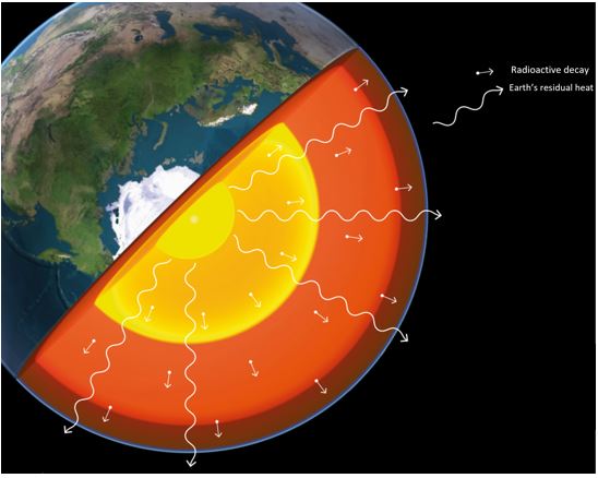 Geothermal energy is a renewable energy source that originates from radioactive decay and residual heat within the Earth, heat that slowly moves out towards the Earth’s crust and into space. Geothermal energy is an infinite energy source, is not dependent on the weather (unlike solar, wind and wave power) and has a low carbon footprint. In Denmark, the energy can be utilized as hot saline water from geothermal sandstone reservoirs. In the Danish subsurface, the temperature rises ca 25ºC for each km depth, dependent on the thermal conductivity of the rock type and location. Sandstone and chalk have relatively high thermal conductivity allowing heat to pass through, and clay has low thermal conductivity and holds heat in. [image: https://www.geoviden.dk/dyb-geotermi-i-danmark/]
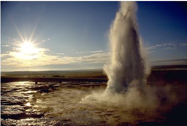
Iceland is located on a hotspot so the geothermal energy source is close to the surface (The Strokkur Geysir; image - Andreas Tille https://commons.wikimedia.org).
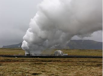
Iceland is a pioneer in the use of geothermal energy for heating and electricity production (Hellisheiði Geothermal plant; image - Hansueli Krapf https://commons.wikimedia.org).

Geothermal energy provides heat for 90% of houses in Iceland and a quarter of Iceland’s electricity, as well as e.g. heating swimming pools (The Blue Lagoon; image - Javier Olivares https://commons.wikimedia.org) and greenhouses and for powering industry.
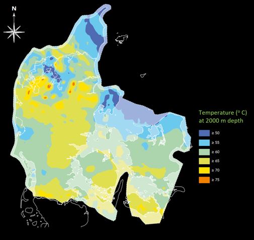 Denmark is not located where molten rock is close to the surface, but saline water at depth is hot enough to be exploited for geothermal energy. The map (image - https://www.geoviden.dk/dyb-geotermi-i-danmark/) shows the temperature of the Danish subsurface at 2 km depth. The difference in temperature reflects the different rock types found from the surface to 2 km depth.
 The Danish subsurface contains so much warm water that in principle it could provide up to a half of Denmark’s annual heating, but due to earlier dependence on other energy sources, the geothermal energy industry, on a wide scale, is still relatively new. Locally, however, hot water from geothermal energy is used for district heating. Warm water from an underground reservoir is pumped up to a geothermal plant at the surface, where the heat is extracted using a heat exchanger and transferred to the district heating network. At the same time cooled reservoir water is sent back into the ground, where it is warmed up again. (See 3D cube model; image - https://dybgeotermi.geus.dk/en)
In Denmark, the optimal geothermal reservoir rock is sandstone. Sandstone thickness is essential as the reservoir needs to hold enough water. As a rule of thumb, the sandstone reservoir has to be at depths between 800-3000 m where water temperature is between 35-90ºC (see map below). Water has to be of a certain minimum temperature to ensure that enough heat can be extracted. If the sandstone is too deeply buried in the subsurface, its porosity may be too low, and consequently its reservoir quality too poor.
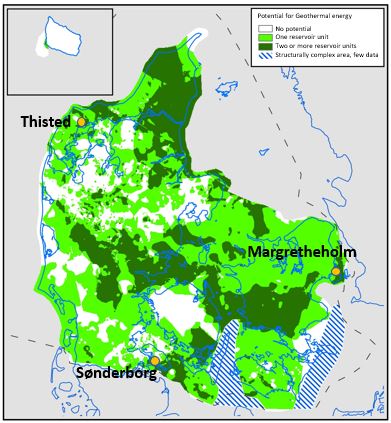 The map (left) shows the Danish subsurface and where sandstone reservoirs with the potential for geothermal energy extraction can be found. The localities of 3 geothermal facilities: Thisted, Margretheholm and Sønderborg, are shown. (https://eng.geus.dk/products-services-facilities/data-and-maps/deep-geothermal-energy-portal)
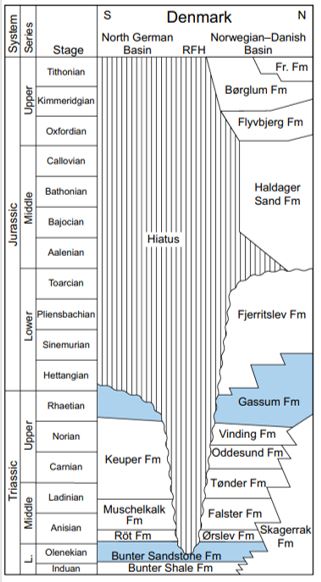
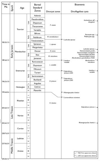
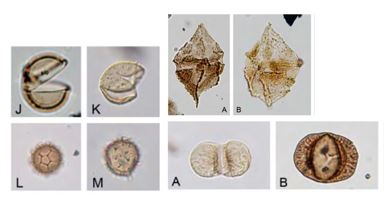
In Denmark the main deep geothermal reservoirs are the Lower Triassic Bunter Sandstone Formation and the Upper Triassic/Lower Jurassic Gassum Formation. Other formations with reservoir potential are the Triassic Skagerrak Formation, the middle Jurassic Haldager Sand Formation and the Upper Jurassic Flyvbjerg and Frederikshavn formations (See Lithostratigraphy image below. The main geothermal reservoirs shown in blue - after Kristensen et al., 2016.). Biostratigraphy, in particular palynology (e.g. spores, pollen, dinoflagellate cysts) is essential when mapping and correlating the geothermal reservoir levels and their seals (See Biostratigraphy zonation scheme below - after Vosgerau et al. 2016, with palynomorph photos after Lindstrom et al., in press).
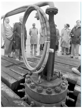 Thisted geothermal plant in Jutland, Denmark (black & white photo left: Thisted inauguration ceremony of 1984; image - local history archive, Thy (https://www.geoviden.dk/dyb-geotermi-i-danmark/)), has provided heat from geothermal energy since 1984. It uses water from the Gassum Formation at a depth of ca 1200 m where water is ca. 45ºC.
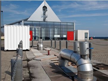
The Margretheholm Geothermal Plant near Copenhagen (see photo above; image - Peter Warna-Moors, GEUS) was built in 2005. It uses water from the Bunter Sandstone Formation which is 2.6 km deep where water is ca. 73ºC. The overburden includes the Upper Cretaceous chalks (see seismic image below) but the nature of these is poorly understood. A biostratigraphic breakdown of the chalk of the Margretheholm-1 geothermal well was carried out using calcareous nannofossils (see nannofossil biostrat image below - after Kristensen et al., 2017 and fossil photos after Sheldon, 2008). It was the first time a detailed combined bio-, litho- and log stratigraphic study had been conducted on a deep well penetrating all of the Upper Cretaceous section onshore Denmark, providing important correlation with other local and regional boreholes (see correlation image below - after Kristensen et al., 2017), increasing understanding of the regional geology, which is crucial for current and future geothermal energy development.
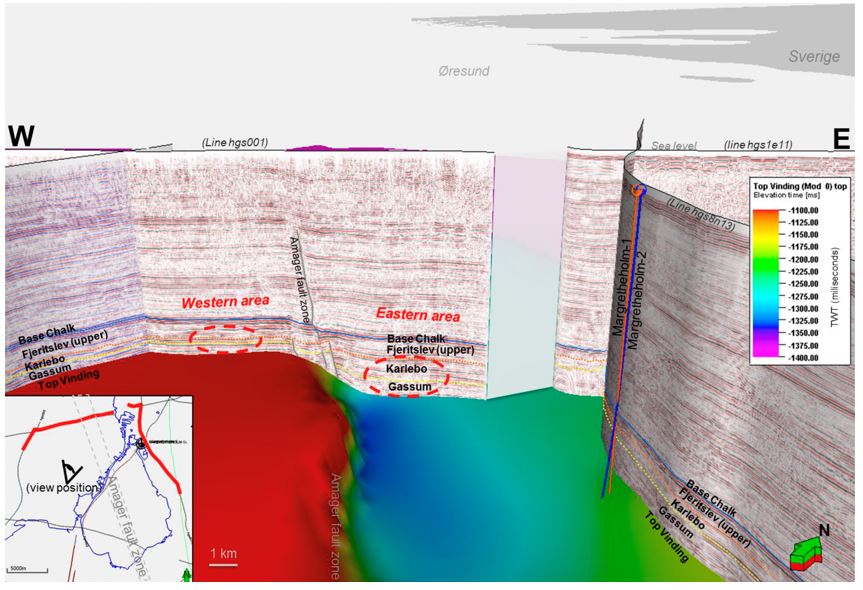
3D seismic north towards Copenhagen and the Margretheholm geothermal wells, showing structural complexity across the Amager fault zone and large thickness of chalk overlying Gassum Formation reservoir. A biostratigraphic breakdown of the chalk is based on nannofossils and is key to regional correlation. In Vosgerau et al., 2016.
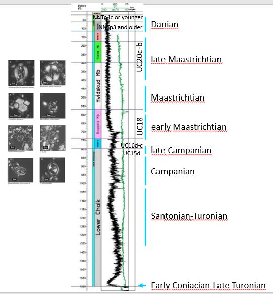
Nannofossil biostratigraphic breakdown of the Upper Cretaceous chalk of the Margretheholm-1 well 30m – 1635m. (Kristensen et al. 2017), plus selected Upper Cretaceous nannofossils from onshore Denmark (Sheldon, 2008).
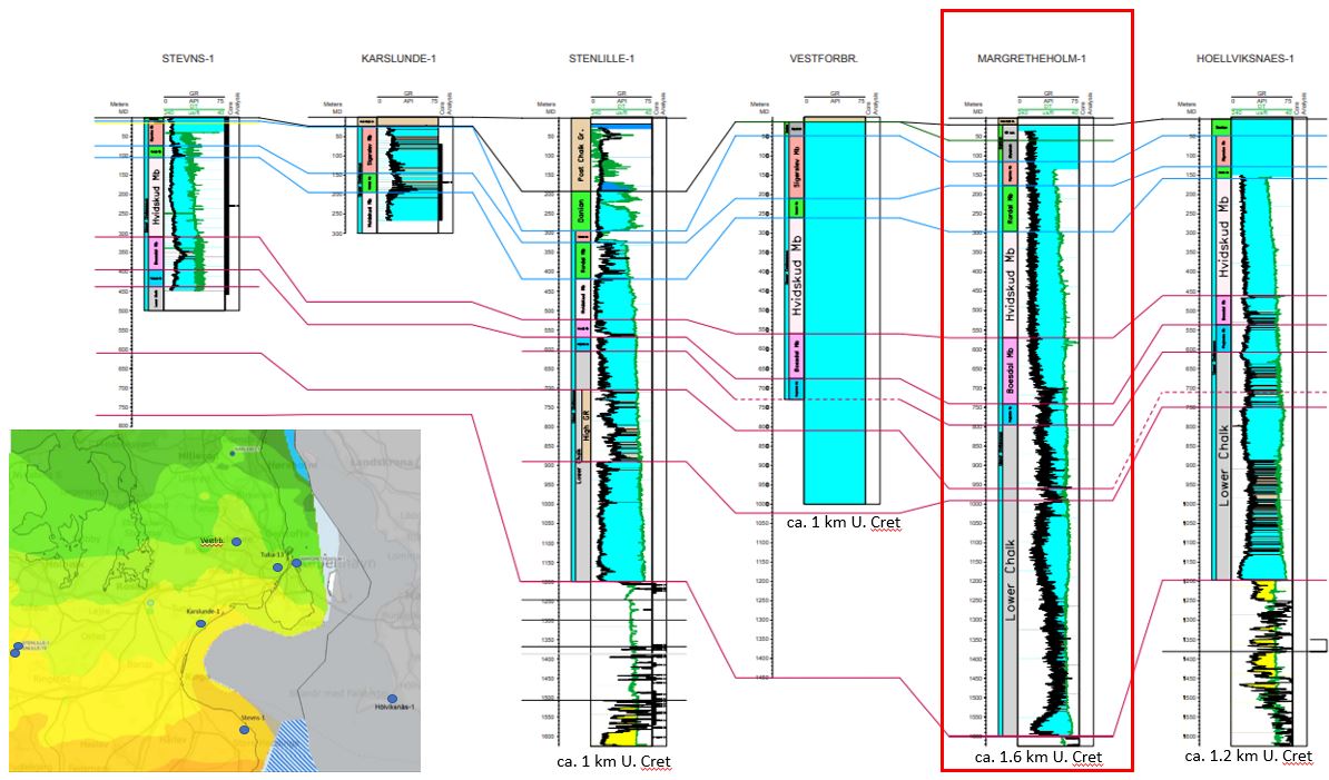
Correlation and lithostratigraphic subdivision of wells in the greater Copenhagen area drilled in the Upper Cretaceous Chalk Group Equivalent (light blue). The Margretheholm-1 geothermal well is highlighted in the red box. (Kristensen et al., 2017).

Seismic surveys: vibrations from the trucks reach 5 km underground and are then received by geophones on the ground. The data collected allows mapping of the subsurface to localise the geothermal reservoirs. In Spring and summer 2023 the geothermal company Innargi are carrying out new seismic surveys around Denmark to map the subsurface in order to localise potential geothermal reservoirs (see seismic trucks and map below - images from https://www.innargi.com).