
Table of Contents
The Maximum Regressive Surface (MRS)
(Sometimes known as the Transgressive Surface (TS) although the two are not strictly the same).
Technically this represents the peak regression and offlap at the top of the LST, separating regressive from overlying transgressive sediments. It broadly coincides with the lowest relative sea level. It is also sometimes known as the Transgressive Surface (TS). The MRS/TS is shown in green in the figures herein.
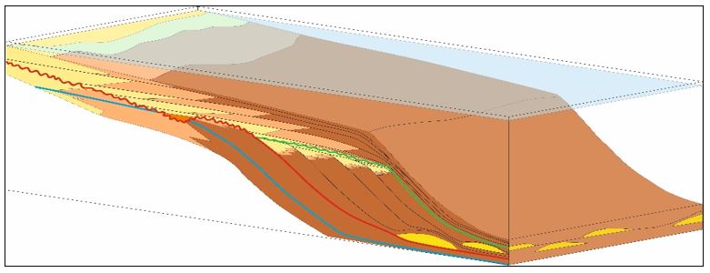
The MRS shown as a green line. It is immediately followed by deposition of the Transgressive Systems Tract (TST).
Regression - what is it?
It is also useful here to distinguish between “normal” and “forced” regression as the two terms can appear counter-intuitive.
Most geologists loosely associate regression with sea level fall and the coastline moving away from the hinterland and towards the basin centre. However true regression is actually a function of sediment supply, not sea level fall – where an excess of sediment supply drives the shoreline basinwards – essentially it is a prograding series of sediments which aggrade (aggradation) basinwards.
Sedimentation rate outpaces any rise in relative sea level. Forced regression is actually the one driven by sea level fall. The coastline is effectively “forced” to regress (move basinwards) irrespective of the actual sediment supply, by falling sea levels. This results again in a prograding series of sediments, but with downstepping rather than aggradation.
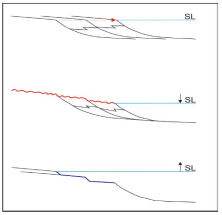
(Upper part) - Normal regression – progradation with aggradation; (middle) – Forced regression – progradation with downstepping and (lower) – Transgression – retrogradation. (Modified from Catuneanu, 2006).