
Table of Contents
Geostopping
Geostopping involves the identification by the biostratigrapher of a specific target horizon based on a specific index fossil or marker species or assemblage of species known to be characteristic of that horizon. Such a target horizon is pre-selected as a proxy at which a desired drilling event is required to happen. Such an event may not necessarily depend on reaching a specific measured depth, but is related to something in the overall geological/stratigraphic setting which effects engineering, safety or cost decisions. Such horizons would include…
- Coring points
- Casing points
- TD horizons
In all of the above cases, drilling on past the desired horizon would involve negative effects on costs, engineering or safety and therefore need to be accurately controlled.
A common requirement at wellsite is to place casing in an optimum position, for example, prior to entering a reservoir. In some cases it is possible to penetrate the upper few feet of the reservoir (and confirm its position) but in others, penetration of the reservoir will result is sufficient change in internal pore pressure so that the pressure differential between the reservoir and the overlying seal with cause problems sufficient to disrupt drilling, or worse. The job of the casing is to control the formation and its internal pressures to which it applies and allows a change in drilling parameters which are required to drill the next (reservoir) section safely.
Gorm Field Casing Pick (North Sea)
The Gorm Field in the Danish sector of the North Sea demonstrates such a scenario. The reservoir is a chalk limestone overlain by a seal of claystones with a thin (c.2m thick) “transition zone” of marl in between. The reservoir in underpressured with respect to the claystones which means if penetrated by the drill, the heavy mud necessary to control the claystones is too dense to avoid entering the reservoir (by overcoming the lower internal pore pressure of the chalks) and damaging it. In addition – mechanically – the situation normally results in the drill becoming “stuck” in the formation. This usually results in an expensive and time-consuming operation to rectify the situation, often requiring the redrilling of the original well and the abandonment of much expensive drilling hardware.
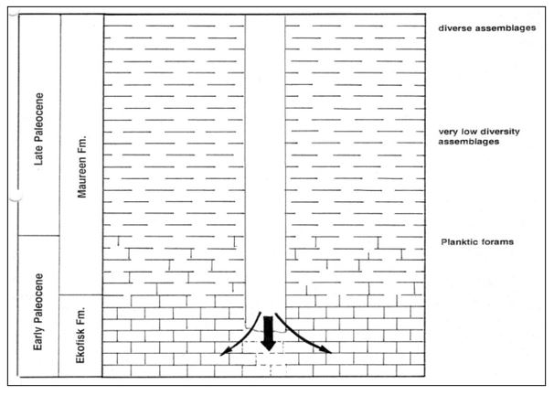
Penetrating the reservoir (limestones) without casing off the overlying borehole results in formation damage, lost equipment and lost time. Ideally drilling into the marly transition zone and then stopping to set casing before drilling ahead is the solution but this interval is only c.2 metres thick and its precise depth below the surface cannot be accurately calculated.
The essence of the problem is that the drill needs to stop as close to the reservoir as possible, but not to actually penetrate it. Ideally, the drilling would cease within the 2m window of the “transition zone” marls and the casing set within that unit. The exact depth to be drilled to the top of the “transitional zone” or the reservoir is unknown to the accuracy required and cannot be determined by seismic interpretation. Further exploitation of the reservoir was becoming uneconomic. Each development well was costing in the region of $2 million extra to cover the loss of drilling mud and drilling equipment and the operator was questioning the field’s future.
It was thought that wellsite biostratigraphy may be able to help with a more accurate determination of the claystone layers immediately above the “transition zone” and reservoir, but standard biozones do not have the required resolution to be able to determine this. In addition, biozones delineate an interval of geological time as expressed by the range(s) of fossil organisms, not rock thickness.
A solution was found by examining closely-spaced samples from nearby wells and producing a high-resolution biozonation scheme which utilised a pragmatic set of fossil events, specific to the Gorm Field and the surrounding areas, and to use a wellsite biostratigrapher to monitor closely-spaced samples taken on the approach to the reservoir section. It can be seen (see below) that these fossil events accurately define the target horizon which is the “transitional marls” immediately above the reservoir. More importantly, it also shows a series of closely-spaced subzones defined by separate fossil events which can be used to “flag” the approach of the target horizon. These subzones – because they are an expression of the local geology – may even be used to estimate rock thickness and provide estimates in actual distances to be drilled between marker events.
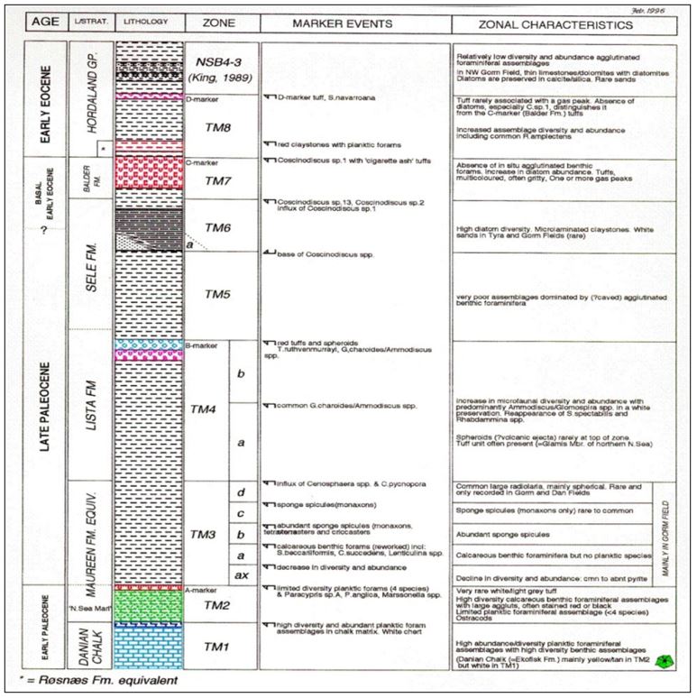
Chart showing closely-spaced biostratigraphic events to warn of the impending arrival of the drill string in the target zone (green unit) just above the underpressured reservoir (blue unit). When the markers for higher zones like TM7 to TM4 were observed in the samples, the ROP could be controlled to allow closely-spaced samples to be taken to look for markers TM3 d, c, b, a and ax. When markers for TM2 were seen drilling could be stopped quickly without risk of penetrating the reservoir (TM1).
The technique was used on the subsequent 12 production wells drilled with no “lost holes” thereby estimating a saving of $24 million by not losing any redrilling time or drilling equipment. The estimated life span of the field was also increased because of the increased confidence in future safe drilling.